Client: Various Clients throughout Oregon and Washington Prepared detailed ALTA/ASCM surveys for over 40 commercial, retail and office properties located throughout Oregon and Washington. These surveys were often used for property acquisitions, re-financing, or as the basis for design of new or expanded facitilities. Sites ranged in size from 1 acre, to 40+ acre retail/commercial […]
South Central C Utility Upgrades

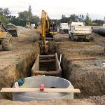
Client: City of Beaverton, Oregon. The project consisted of 15,000 lineal feet of roadway and private property surveying for sanitary sewer, storm sewer and waterline upgrades and replacements. CESNW established GPS and conventional control network compatible with the City of Beaverton’s. Surveying included topographic mapping, right-of-way and easement location determination, coordinating with utility companies and […]
Harvest Hills Low Impact Development
Client: Clean Water Services, Oregon. Surveying services included right-of-way location, topographic surveying, base map preparation and legal description preparation. The project included providing a design survey for over 4000 lineal feet of sanitary sewer lines. The sewer line route included backyards of residences, creek and canyon areas as well as existing streets.
Fire Hydrant GIS/Mapping & Database

Client: Murray Smith Engineering/City of Beaverton, Oregon. CESNW inventoried and mapped over 2,400 fire hydrants within the City of Beaverton. Work products included a data base with manufacturer, date, type, number of ports, and port size of each hydrant; along with horizontal and vertical locations with GIS level of accuracy. In addition to the data […]
Wetland Mitigation Cook Park
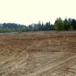
Client: City of Tigard, Oregon The City of Tigard was required to create approximately 5 acres of new wetlands to mitigate for various wetland impacts associated with expansion of Cook Park and other projects. CESNW provided surveying for the topographic mapping and construction staking; civil engineering for the grading and utility plans; and preparation of […]